Eppalock South
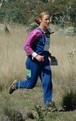
Bush orienteering out near Lake Eppalock. Lovely open runnable forest, and I did lots of lovely open running. Only problem was that a fair chunk of it was in the wrong direction. *rolls eyes*
The courses were longer than usual but they had fewer controls than normal. My course was 7.7 km and had 8 controls (usually 12-16). With an average of a km between controls, and not a lot of map detail, that makes for a lot of opportunities to veer off course.
My first stuff-up was control #3. Take a bearing, and the general idea was to "run in that direction until I hit a road." Off and running - only to come across a large erosion gully that wasn't meant to be there. And no sign of a road. WTF? I relocate with the help of Ilse (also off-course, although not as badly), find the road about a km away, then up a hill and down the saddle. Only I screw it up again and have to relocate off another track. Urgh! 30 minutes to that control.
Then I do it again with control #4. Spur, track, gully, knoll, and follow the tops. How hard could it be?? No joy - down to the track to relocate, only I'm on a different track to the one that I think I'm on, and the compass and the gullies don't add up. I eventually surrender and walk down to a really, really large road and relocate off that. Grrr, another 33 minutes gone.
Fumbled my way around the rest of the course without too many dramas, but never really "got into" the map. Finished second to last, but there were 3 people who "mispunched" (or gave up).
Nice run though. Nice clear, sunny day out west - Melbourne city looked pretty miserable in comparison.
Course: 4 (W35A)
Course Distance: 7.7 km
Actual Distance: 12.6 km
Time Taken: 2:13
The week that was
| Weight | 72.5 kgs |
| Walking | 22.9 kms |
| Running | 34.2 kms |


No comments:
Post a Comment