Bush Orienteering Weekend
SATURDAY: Still in bed at 8 o'clock listening to the rain, wondering if I can be bothered going orienteering this weekend. Course opens at 10 o'clock, it'll take me 2 1/2 hours to get to Daylesford, and I haven't organised anything.
Up, breakfast, throw some clothes into one bag, food into another bag, and on the road by 9:20, wondering what I've forgotten!
Arrive at the venue around 11:45 - I'm one of the last to start at 12:30. Horror start - I take 27 minutes to the first control, and blunder through the rest. 11.1 kms in 2:18. The rain holds off until the last 2 minutes, and I'm hot in my thermal singlet (rain protection), and there's no water left at the water stops. I have the Gizmo recording my route, and I'm setting the lap timer at each control, so I'm well aware of how slowly I'm going! I finish eventually, and the organisers are starting to pack up.
There is a big mud slide at the gate into the paddock where we're parked, and better cars than mine have slipped and slided getting out, so I'm a tad nervous in my small 2WD. However, no problems. I take careful aim, take a good runup on the grass, and I'm through the gate and over the mud, slipping my way up the forest road towards the safety of gravel.
Drive through to Castlemaine and spend the night at the Northern Hotel in backpacker accommodation.
SUNDAY: Still in bed at 8 o'clock... hah hah... but the event is only 5 minutes up the road at the Castlemaine secondary school.
This time I'm one of the first to start, and have a better run for 6.8 kms in 1:28. No serious blunders, however we're using manual punches instead of the electronic Sport Ident system, and I keep forgetting to hit the lap counter on the Gizmo. However, I have no energy, and find it hard to run the hills.
Home by mid-afternoon.
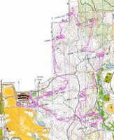
Finally figured how to marry up an orienteering map with the Garmin output - without the fancy mapping software. Scan the map; turn the Garmin track into a jpeg using GPS Visualizer; and use PaintShop Pro to layer the two. It's not perfect - I have to manually "Deform" the track to make it fit the map. Even then, there are inaccuraces - due, I think, to gaps in the sattelite tracking. There are tracks and gullies that I follow that the Garmin doesn't record, but it's useful to see why I stuffed up #5 today, for example, by heading up a parallel gully.
Anyway - click on one of the pictures to see the end result.
Butterfly Gully (Saturday)
Castlemaine (Sunday)


No comments:
Post a Comment