
Queen's Birthday Weekend
Bush orienteering up near Albury. I drove up on Saturday afternoon (after deciding that it was too cold at home to do any more painting) and arrived at the Lake Hume Tourist Park in time for "Suburu Salad" with Pete and Ilse and the Dodd's.
Ilse had rescued me from a couple of very cold nights in my (new) tent, and offered me one of the spare beds in their cabin. Very much appreciated, especially this morning when we woke to a sub-zero frost.
SUN: Mount Terrible
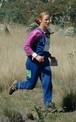
Not so terrible. Nice open forest and easy running. Doing well until I did my FIRST EVER 180. Headed off from control #4, cross the track, down the gully, found the control... hang on. That's not a pit... that's not my control. Checked my clue sheet - and found that I was at control #9. WTF?? "Oh, you stupid girl" (out loud). I'd taken a bearing with the map effectively upside down, and headed east instead of west. Grrr. 15+ minutes wasted.
Then after leaving control #15 I nearly knocked myself out. Running across a slope, my uphill foot slid about a metre down a slippery twig and I went down hard. I landed heavily on my hip and upper leg - creating a lovely bruise on my thigh and a matching one on my upper arm. Experienced a bit of brain fade after that (still in shock) and walked the last few controls home.
Course: 4 (W35A), 17 controls
Course Length: 5.4 km
Actual Distance: 7.7 km (MB has 8.4 km with 932m climb)
Time Taken: 1:51
MON: Barambogie South
Terrible. I was still fatigued from yesterday, and this map was a thousand times more physically challenging. Very steep climbs through thick scrub and large rocks. Found #1 easily; took the scenic route to #2; #3 was straightforward; a huge climb uphill to #4 (84m climb in 245m!). By control #5, I was starting to feel a bit flakey; I walked straight past #6; and by control #7, I was stumbling around looking behind every rock with no real idea of what I was doing. Time to call it quits - complete system failure: my brain was fried, and my feet weren't too far behind.
Course: 4 (W35A), 13 controls
Course Length: 5.3 km
Actual Distance: 6.9 km DNF (MB has 8.2 km with 1212m climb)
Time Taken: 2:11
Weekly wrap:
| Weight | 70.9 kgs ▼ |
| Walking | 5.1 kms |
| Running | 38.9 kms |
| Cycling | 37.5 kms |
![]()


No comments:
Post a Comment